Search Results for: “Cornwall”
Cornwall, The Homeland Handbooks - Looe, Fowey and Polperro with their surroundings (Approx. 1915) Special Offer
This guide provides invaluable background information on Looe, Fowey and Polperro with their surroundings in the 1900's. This official council guide has maps, photographs and illustrations. It covers the history, traditions, worthies, antiquities and literary associations. This is a useful guide with information and details about the area where your relatives may have lived. *Digitally enhanced images of the original text *Includes maps, photographs and illustrations *Bookmarked by major head... More Info
Cornwall, The Homeland Handbooks - Newquay , the Vale of Lanherne & Perranzabuloe circa 1930 Special Offer
This guide provides invaluable background information on Newquay , the Vale of Lanherne and Perranzabuloe in the 1900's. This official council guide has maps, photographs and illustrations. It covers the history, traditions, worthies, antiquities and literary associations. * Digitally enhanced images of the original text * Includes maps, photographs and illustrations * Searchable by whole or part name * Bookmarked by major headings * Fully printable... More Info
Can't find what you're looking for? Try using our filter system to narrow down your search.
Available through our sister site GenFair
THE CORNWALL MILITARY SURVEY OF 1522 with the LOAN BOOKS AND TINNERS MUSTER OF 1535 Edited by T. L. Stoate
In 1522 Wolsey, Henry VIII's chancellor, was badly in need of money to finance the war with France . A subsidy in 1514 failed to raise the expected amount and had to be repeated in 1515 and 1516. He was planning another subsidy and it is presumed that he did not think that satisfactory assessments would be made for it. He therefore ordered a new and extensive survey of the wealth of the country bo...More Info
THE CIRCLE OR HISTORICAL SURVEY OF SIXTY TOWNS AND PARISHES IN CORNWALL printed and published by William Penaluna
This book was first published in 1819 and covers sixty towns and parishes giving a brief description of the parish at that time and its history. The following parishes appear; Breage, Budock, Camborne, Constantine, Crowan, Cury, Falmouth, Feock, Germoe, Grade, Gulval, Gunwalloe, Gwennap, Gwinear, Gwithian, Helston, Illogan, Kea, Kenwyn, Lalant, Landewednack, Ludgvan, Mabe, Madron, Marazion, Ma...More Info
HERALDIC CHURCH NOTES from CORNWALL by Arthur J. Jewers
This publication contains all the Heraldry and Genealogical Particulars on every Memorial in the Ten Churches in the Deanery of East. Annotated with notes from Wills etc. The following churches are covered, Rame, St. Johns, Sheviock, Saltash, East Antony, St. Germans, St. Stephens, Botus Fleming, St. Dominick and Maker
HIGHWAYS AND BYWAYS OF DEVON AND CORNWALL by Arthur H. Norway with illustrations by Joseph Pannell and Hugh Thomson
This book was published in 1897 and is a superb guide to these two counties. It gives an accurate and interesting description of the various towns and villages with contemporary antidotes. History is not forgotten and a large portion of each chapter is devoted to the historical facts, which is written in a such a way as to make it very enjoyable reading. There are almost four hundred pages with n...More Info
CORNWALL 1787
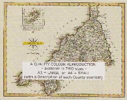
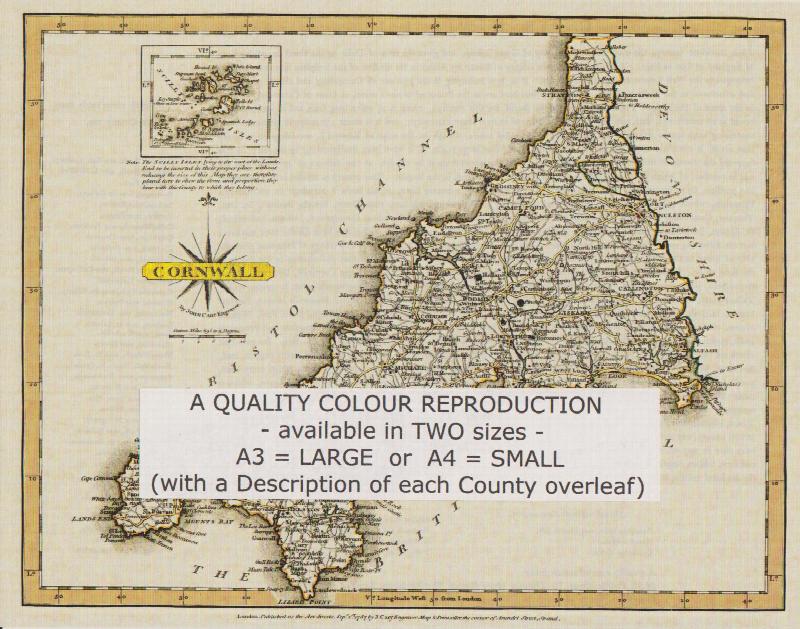
A QUALITY A3 SIZE COLOUR REPRODUCTION FROM JOHN CARY'S 1787 ATLAS WITH DETAILS OF THE COUNTY OVERLEAF. LASER PRINTER ON GOOD QUALITY CARTRIDGE PAPER. SENT FOLDED IN A PLASTIC DISPLAY SLEEVE IN A STIFF CARD ENVELOPE AT THE LARGE LETTER RATE. SCALES VARY